18. SpaceNo. 18.27
Real Moons
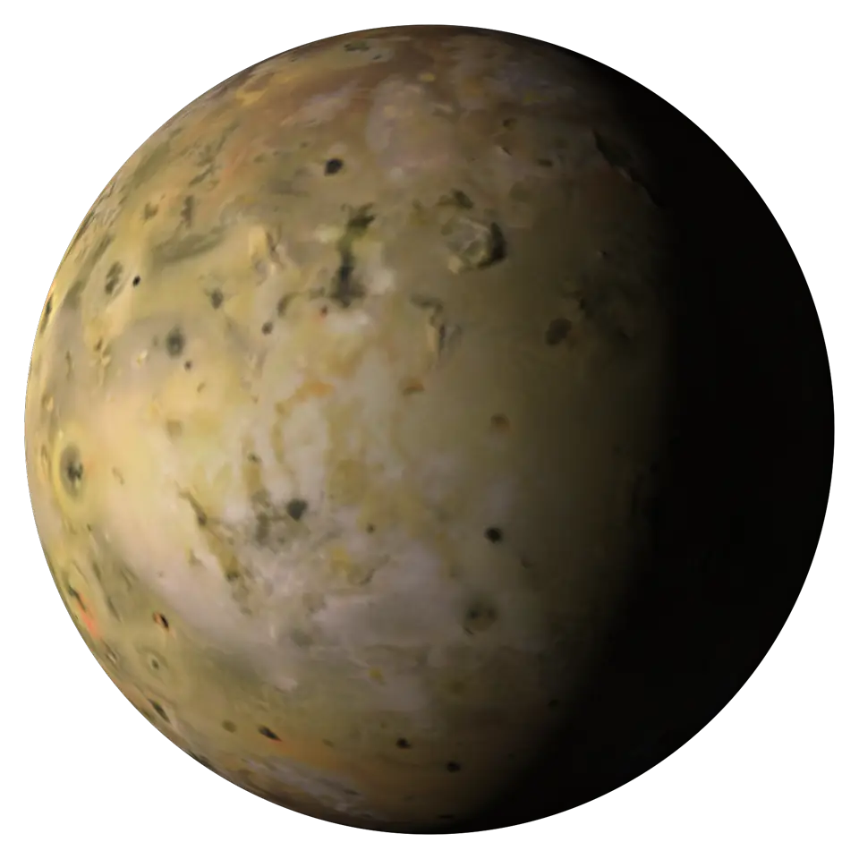
Five big moons from USGS maps of pictures by the Voyager, Galileo and Cassini spacecraft: volcanic Io; Europa, cracked ice over a hidden ocean; Ganymede, the largest moon in the solar system; cratered Callisto; and Saturn's moon Titan, with lakes of liquid methane and ethane.
Handling
Pick a moon in the Splash tab. Tap a spot to zoom in and name it; tap again to go out.
Its tag
- Shelf
- 18. Space
- Kind
- Built from a recipe
- Made from
- The big moons of Jupiter and Saturn, from the Voyager, Galileo and Cassini spacecraft. Real maps (no elevation map exists for these, so the ground is smooth); the turning is scaled as chosen above, and the sun can be moved. A tap zooms in on that spot as far as the maps allow and names what is there (the IAU's named features); a second tap goes back out.
- Sound
- Yes
- Licenses
- Public domain
On the wall it weighs 12.5 KB: 1,019 splats, fitted to pictures of the full Splash, which opens with 294,973.
Its controls
| Control | Kind | Range | Start |
|---|---|---|---|
| Tap a spot to zoom in and name it (the play button flies to a named feature) | Tap | ||
| Sun | Slider | 0 to 100% | 33% |
| Fly to a feature | Button | ||
| Zoom in on a spot | Button | ||
| World | List | 5 choices | Io |
| Turning | List | 3 choices | 86,400× real speed (a day a second) |
About it
Five big moons from USGS maps of pictures by the Voyager, Galileo and Cassini spacecraft: volcanic Io; Europa, cracked ice over a hidden ocean; Ganymede, the largest moon in the solar system; cratered Callisto; and Saturn's moon Titan, with lakes of liquid methane and ethane.
No spacecraft has mapped these moons' heights all the way round, so their ground is drawn smooth, in the moons' own colors (gray where the map is black and white). Titan's map was taken through its orange haze in near-infrared light, and the haze is left out. Seams show where the maps' pictures were lit differently. Each moon keeps one face toward its planet; here a day passes each second. A tap zooms in and names the spot from the IAU's list; tap again to go out.
Is it right?
5 worlds drawn from real maps (Io, Europa, Ganymede, Callisto, Titan): every splat has its place's measured color, and each named feature is where the planetary gazetteer puts it. The turning speed and the lighting are simplified, and labeled.
Correct
The color map is Io Galileo SSI / Voyager Global Mosaic, color merge, 1 km.1
tools/sp2-maps.mjs reads the source file named in src/space/worlds.js and averages it into the splash's smaller maps (east longitudes from -180° to 180°).
Correct
Io turns once every 42.459 hours (its sidereal day), sped up by the chosen factor.2
Each frame the drive adds the elapsed time times the speed-up, over the day's length, to the turn.
Correct
A tap flies to Pele, a volcano and its red ring of fallout at -18.71°, 104.72° east, and the map shows it there.3
The drive turns the feature's direction to face the viewer and glides the camera to it; the test checks the turn and the map's heights round the listed center.
Correct
A tap flies to Loki Patera, a lava lake at 13.01°, 51.21° east, and the map shows it there.4
The drive turns the feature's direction to face the viewer and glides the camera to it; the test checks the turn and the map's heights round the listed center.
Correct
A tap flies to Prometheus, a volcano at -1.52°, -153.94° east, and the map shows it there.5
The drive turns the feature's direction to face the viewer and glides the camera to it; the test checks the turn and the map's heights round the listed center.
Correct
The map is Europa Voyager / Galileo SSI Global Mosaic 500m.6
tools/sp2-maps.mjs reads the source file named in src/space/worlds.js and averages it into the splash's smaller maps (east longitudes from -180° to 180°).
Correct
Europa turns once every 85.228 hours (its sidereal day), sped up by the chosen factor.2
Each frame the drive adds the elapsed time times the speed-up, over the day's length, to the turn.
Correct
A tap flies to Pwyll crater and its rays at -25.2°, 88.6° east, and the map shows it there.7
The drive turns the feature's direction to face the viewer and glides the camera to it; the test checks the turn and the map's heights round the listed center.
Correct
A tap flies to Conamara Chaos, broken plates of ice at 9.7°, 87.3° east, and the map shows it there.8
The drive turns the feature's direction to face the viewer and glides the camera to it; the test checks the turn and the map's heights round the listed center.
Correct
A tap flies to Tyre, a ringed impact scar at 33.6°, -146.6° east, and the map shows it there.9
The drive turns the feature's direction to face the viewer and glides the camera to it; the test checks the turn and the map's heights round the listed center.
Correct
The color map is Ganymede Voyager / Galileo SSI Global Color Mosaic 1435m.10
tools/sp2-maps.mjs reads the source file named in src/space/worlds.js and averages it into the splash's smaller maps (east longitudes from -180° to 180°).
Correct
Ganymede turns once every 171.71 hours (its sidereal day), sped up by the chosen factor.2
Each frame the drive adds the elapsed time times the speed-up, over the day's length, to the turn.
Correct
A tap flies to Galileo Regio, old dark ground at 45°, -127° east, and the map shows it there.11
The drive turns the feature's direction to face the viewer and glides the camera to it; the test checks the turn and the map's heights round the listed center.
Correct
A tap flies to Osiris, a young rayed crater at -38°, -166.31° east, and the map shows it there.12
The drive turns the feature's direction to face the viewer and glides the camera to it; the test checks the turn and the map's heights round the listed center.
Correct
A tap flies to Tros, a young rayed crater at 11.14°, -27.26° east, and the map shows it there.13
The drive turns the feature's direction to face the viewer and glides the camera to it; the test checks the turn and the map's heights round the listed center.
Correct
The map is Callisto Voyager / Galileo SSI Global Mosaic 1km.14
tools/sp2-maps.mjs reads the source file named in src/space/worlds.js and averages it into the splash's smaller maps (east longitudes from -180° to 180°).
Correct
Callisto turns once every 400.54 hours (its sidereal day), sped up by the chosen factor.2
Each frame the drive adds the elapsed time times the speed-up, over the day's length, to the turn.
Correct
A tap flies to Valhalla, a giant ringed basin at 14.7°, -56° east, and the map shows it there.15
The drive turns the feature's direction to face the viewer and glides the camera to it; the test checks the turn and the map's heights round the listed center.
Correct
A tap flies to Asgard, a ringed basin at 32.2°, -139.9° east, and the map shows it there.16
The drive turns the feature's direction to face the viewer and glides the camera to it; the test checks the turn and the map's heights round the listed center.
Correct
The map is Titan Cassini ISS Global Mosaic 4km.17
tools/sp2-maps.mjs reads the source file named in src/space/worlds.js and averages it into the splash's smaller maps (east longitudes from -180° to 180°).
Correct
Titan turns once every 382.69 hours (its sidereal day), sped up by the chosen factor.18
Each frame the drive adds the elapsed time times the speed-up, over the day's length, to the turn.
Correct
A tap flies to Kraken Mare, a sea of liquid methane and ethane at 68°, 50° east, and the map shows it there.19
The drive turns the feature's direction to face the viewer and glides the camera to it; the test checks the turn and the map's heights round the listed center.
Correct
A tap flies to Xanadu, a bright highland at -15°, -100° east, and the map shows it there.20
The drive turns the feature's direction to face the viewer and glides the camera to it; the test checks the turn and the map's heights round the listed center.
Correct
A tap flies to Selk crater, where the Dragonfly lander is headed at 7°, 161° east, and the map shows it there.21
The drive turns the feature's direction to face the viewer and glides the camera to it; the test checks the turn and the map's heights round the listed center.
Not yet checked
A tap names the place under it: the smallest named feature it lies in, what that lies on, and the plain or highland round it, from the IAU Gazetteer.22
tools/sp3-places.mjs keeps each adopted feature center and size from the Gazetteer downloads; src/space/places.js finds the features a spot lies within (half their listed size from the center). tests/sp3.spec.mjs checks Tycho, Olympus Mons, Gale, Rachmaninoff, Maat Mons and Tranquility Base, and a tap on Tycho and on Olympus Mons in the browser.
Not yet checked
Zoomed in, the ground comes from close-up tiles of the same maps, finer than the global map (the scales are in src/space/zoom.js); a feature named as a circle is an approximation of its real outline.1
tools/sp3-tiles.mjs averages each source into 10° tiles; tests/sp3.spec.mjs checks each world's tiles against its global map at a named feature.
- 1Io Galileo SSI / Voyager Global Mosaic, color merge, 1 km, NASA, JPL, Galileo and Voyager missions; USGS Astrogeology Science Center
- 2Jovian Satellite Fact Sheet, NASA Space Science Data Coordinated Archive
- 3Gazetteer of Planetary Nomenclature, USGS, IAU
- 4Gazetteer of Planetary Nomenclature, USGS, IAU
- 5Gazetteer of Planetary Nomenclature, USGS, IAU
- 6Europa Voyager / Galileo SSI Global Mosaic 500m, NASA, JPL, Galileo and Voyager missions; USGS Astrogeology Science Center
- 7Gazetteer of Planetary Nomenclature, USGS, IAU
- 8Gazetteer of Planetary Nomenclature, USGS, IAU
- 9Gazetteer of Planetary Nomenclature, USGS, IAU
- 10Ganymede Voyager / Galileo SSI Global Color Mosaic 1435m, NASA, JPL, Galileo and Voyager missions; USGS Astrogeology Science Center
- 11Gazetteer of Planetary Nomenclature, USGS, IAU
- 12Gazetteer of Planetary Nomenclature, USGS, IAU
- 13Gazetteer of Planetary Nomenclature, USGS, IAU
- 14Callisto Voyager / Galileo SSI Global Mosaic 1km, NASA, JPL, Galileo and Voyager missions; USGS Astrogeology Science Center
- 15Gazetteer of Planetary Nomenclature, USGS, IAU
- 16Gazetteer of Planetary Nomenclature, USGS, IAU
- 17Titan Cassini ISS Global Mosaic 4km, NASA, JPL, Space Science Institute, Cassini mission; USGS Astrogeology Science Center
- 18Saturnian Satellite Fact Sheet, NASA Space Science Data Coordinated Archive
- 19Gazetteer of Planetary Nomenclature, USGS, IAU
- 20Gazetteer of Planetary Nomenclature, USGS, IAU
- 21Gazetteer of Planetary Nomenclature, USGS, IAU
- 22Gazetteer of Planetary Nomenclature, IAU WGPSN and USGS Astrogeology Science Center
- Simplified
- The world turns thousands of times faster than real (labeled in the Splash tab: an hour or a day each second).
- Simplified
- North is always up and the sun stays near the equator's plane: the axial tilt and the seasons are left out.
- Simplified
- The sun shades each slope by the cosine of its angle to the sun (Lambert's law) and leaves the night side dark, but nothing casts a shadow, and real surfaces scatter light in more complicated ways.
- Simplified
- The global map has about 1,000 by 500 heights and 2,000 by 1,000 colors; only the patches round the named features are sharper.
- Simplified
- Seams between pictures taken under different light show on the map.
- Simplified
- Io has no global elevation map, so its ground is drawn smooth and the relief choice does not apply.
- Simplified
- Europa has no global elevation map, so its ground is drawn smooth and the relief choice does not apply.
- Simplified
- Ganymede has no global elevation map, so its ground is drawn smooth and the relief choice does not apply.
- Simplified
- Callisto has no global elevation map, so its ground is drawn smooth and the relief choice does not apply.
- Simplified
- Titan's thick haze is left out; its map was taken through the haze in near-infrared light, and seams between pictures taken under different light show.
- Simplified
- Titan has no global elevation map, so its ground is drawn smooth and the relief choice does not apply.
Sources and credits
| Work | By | License |
|---|---|---|
| Io Galileo SSI / Voyager Global Mosaic, color merge, 1 km | NASA, JPL, Galileo and Voyager missions; USGS Astrogeology Science Center | Public domain (USGS and NASA) |
| Europa Voyager / Galileo SSI Global Mosaic 500m | NASA, JPL, Galileo and Voyager missions; USGS Astrogeology Science Center | Public domain (USGS and NASA) |
| Ganymede Voyager / Galileo SSI Global Color Mosaic 1435m | NASA, JPL, Galileo and Voyager missions; USGS Astrogeology Science Center | Public domain (USGS and NASA) |
| Callisto Voyager / Galileo SSI Global Mosaic 1km | NASA, JPL, Galileo and Voyager missions; USGS Astrogeology Science Center | Public domain (USGS and NASA) |
| Titan Cassini ISS Global Mosaic 4km | NASA, JPL, Space Science Institute, Cassini mission; USGS Astrogeology Science Center | Public domain (USGS and NASA) |
| Gazetteer of Planetary Nomenclature (center points of the named features) | International Astronomical Union (IAU) Working Group for Planetary System Nomenclature; USGS Astrogeology Science Center | Public domain (USGS) |